...................................
[read in Italian] ![]()
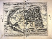
In his introduction to the first plan of Jerusalem (1620, plate 44), showing the city in the author’s time, Bernardino Amico specifies that this image was not originally included in his project, because it was impossible for him to apply his strict perspective method which required to «measure the site geometrically, since if the Moslems got knowledge of it, it could be the cause of serious trouble», as it could be seen as a spy operation. However, after seeing «many plans of several and celebrated authors, all different» and full of negligent mistakes caused by the fact that their authors «confounding among themselves […] had not willed to see site or place» (1620, fol. Pp1r and Plans, p. 130), Amico decided to resume and update the plan of Jerusalem from the Mount of Olives done onsite by a slightly older Fra Antonino De Angelis with the help of Fra Gianfrancesco della Salandra.
| [click sulle immagini per ingrandirle / click on images to enlarge] |

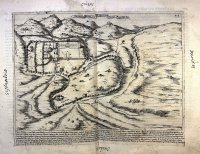
Bernardino Amico’s affinity to Antonino De Angelis and Gianfrancesco della Salandra’s work draws him closer to the proto-archaeological movement, which some friars showed an interest during those years, particularly those who wanted to define the position of the walls of Jerusalem before their reconstruction under Hadrian in 135 A.D. The reason of this study was linked to the actual position of Calvary and consequently of the Holy Sepulchre. Being inside the walls of the Old City (both in Amico’s time and now), Bernardino would like to «remove that bad opinion of some who wish with poor reason to state that this is not the City, but that it has been transferred and that Holy Mount Calvary is found inside it, as is seen in the previous plan; availing themselves of the saying of St. Paul to the Hebrews Chapter 13, 12: Christus extra portam passus est. And they add: even to-day it is inside, therefore it has been transferred» (1620, fol. Qq1r and Plans, p. 134).
The debate on the position of the Holy Sepulchre had already started then. For instance, in his 1587 Devotissimo viaggio di Gerusalemme, the Belgian Jean Zuallart places a plan of the city where a line shows where the walls could have been in Jesus’ time, leaving the Calvary outside (p. 131). Many others shared this opinion. Amico himself followed this position, presenting his own plan, where the city is seen from the West instead of East (1620, plate 45), and looking for sources that could prove this assumption. His main source is The Jewish War by Flavius Josephus (1st century A.D.). Thanks to this text Amico examines the names of the towers and tries to determine which was the city wall of Jerusalem in the first century, proving that Calvary was outside.